精读笔记
Problem Setting
论文标题:Real-Time LiDAR Gaussian Splatting SLAM(arXiv preprint / 2026-07-07)。这篇论文不是在解决一般 LiDAR odometry,也不是单纯把点云渲染成更好看的 dense map;它实际瞄准的是 LiDAR-only、online、大规模序列中,如何让 Gaussian Splatting 成为可用于 SLAM 的 persistent dense map。真正困难点在于 GS 是显式 dense primitive,天然会随 keyframe 增长;LiDAR 又没有 RGB 那种 dense photometric signal,导致 Gaussian 的 orientation、scale、opacity 很难稳定优化;一旦早期 primitive 错了,它还会反过来污染 scan-to-map registration。以前路线要么保留 sparse/voxel map 保实时性但牺牲连续表面,要么用 neural/TSDF/GS 做 dense mapping 但在线代价高、长序列不稳。关键矛盾是:dense representation 需要足够多 primitive 才有 fidelity,而 SLAM tracking 又要求地图小、稳定、可注册、可更新。
Motivation
已有 LiDAR SLAM 的 map representation 本质上是为 registration 服务的,不是为高保真几何重建服务;已有 GS-SLAM 大多继承视觉 GS 的 photometric optimization 思路,但 LiDAR-only 场景里 appearance 不存在,depth/range supervision 又稀疏且带强传感器几何偏置。作者真正抓住的缺口是:LiDAR tracking 已经在 G-ICP 中估计了局部 covariance,而这些 covariance 没有被充分利用。它们不仅描述点的局部平面/线性/曲率结构,也提供了 uncertainty、normal、anisotropic scale 和几何复杂度的低成本信号。换句话说,论文的动机不是“再设计一个更复杂的 mapper”,而是把 tracking 阶段已经付过计算成本的几何统计,变成 mapping 的 inductive bias,并让 mapping 的结果再改善 tracking target。
Core Idea
核心思想可以概括为:用 covariance 作为 tracking 和 mapping 之间的共享几何货币。tracking 阶段的 G-ICP covariance 不再只是优化 pose 的中间量,而被提升为 Gaussian map 的初始化先验、局部 surface orientation、range-aware scale、confidence 和 map-budget control signal;mapping 优化后的 Gaussian orientation/scale/opacity 又被重新解释成下一轮 G-ICP 的 surfel covariance 和可靠性权重。
这个做法改变了 LiDAR GS-SLAM 的信息流:prior work 往往是 tracking 给 mapping pose,mapping 被动累积或优化地图;这里 tracking 给 mapping 的是局部几何统计,mapping 返回 tracking 的是更好的概率化注册目标。它引入的 inductive bias 很明确:LiDAR surface primitive 应该是局部低维、各向异性、带观测可靠性的 surfel-like Gaussian,而不是视觉 3DGS 中为了 radiance rendering 学出来的自由 blob。这也是它比纯 GS mapping 或 neural field 更 scalable 的原因之一:地图容量不是均匀增长,而是由几何复杂度调度。
Method
第一,表示层面使用 spherical-domain 2D anisotropic Gaussian,而不是直接照搬视觉 3DGS 的 volumetric/radiance primitive。它解决的是 LiDAR observation 与 representation 不匹配的问题:LiDAR 是 range image-like 的角度采样,2D surface-oriented Gaussian 更接近真实观测的局部面片,也更容易从 covariance 得到 tangent scale 和 normal。
第二,tracking-to-mapping 的 covariance reuse 是方法的主轴。G-ICP 已经估计每个 downsampled point 的局部 covariance,作者用其 eigenvectors/eigenvalues 初始化 Gaussian rotation、in-plane scale、normal 和 confidence。这个机制解决 sparse LiDAR supervision 下 GS 优化不稳定的问题;核心变化是把 Gaussian 初始化从近似 blind optimization 变成 geometry-informed optimization。
第三,mapping-to-tracking feedback 把优化后的 Gaussian 当成 covariance-aware registration target。Gaussian 的 orientation 和 scale 定义 target covariance,opacity 与物理 confidence 参与 filtering/weighting。它解决的是长期 scan-to-map 中 target 点质量参差、map-side kNN covariance 昂贵的问题;核心变化是 target uncertainty 由 map primitive 直接给出,避免每帧在地图上重估局部结构。
第四,map budget control 用 covariance-derived control score 区分 planar redundancy 和 structural complexity。低 score 的大平面做 cover-and-prune,高 score 的边缘/角点做 splitting。它解决的是 GS map 随时间线性膨胀的问题;核心变化是 representation capacity 被分配到对 tracking 和 reconstruction 都更有信息量的位置,而不是简单 opacity pruning。
Key Insight / Why It Works
最关键的有效性来源是 representation alignment 和 memory reuse。LiDAR 的局部几何结构在 G-ICP covariance 里已经被估计过一次;把它复用到 GS map,等于用几乎零额外成本给每个 primitive 加了局部 surface prior。这个 prior 对 LiDAR-only GS 特别重要,因为没有 photometric texture 来约束 Gaussian 的形状和可见性。
第二个核心点是把 GS 从“渲染表示”改造成“可注册的概率 surfel map”。如果 Gaussian 的 orientation/scale 能被优化得更接近局部 surface,它就不只是 dense reconstruction primitive,也能作为更好的 scan-to-map target covariance。这解释了为什么 full feedback 同时改善 ATE 和 tracking FPS:不是 mapping 在额外修正 tracking,而是 target condition number 和 correspondence reliability 变好了。
第三个点是 scaling,但不是简单堆 GPU 或降采样。control score 实际是在做结构感知的 capacity allocation:平面区域用少数大 primitive 覆盖,复杂区域保留/增加 primitive。这和经典 feature-based LiDAR SLAM 的思想相通:边缘、角点、法向变化处对 pose 和形状更有信息;区别是这里这个思想被用于 dense Gaussian map 的预算管理。
哪些可能只是辅助:opacity initialization、incidence/range confidence、normal scheduling、scale regularization 都合理,但更像稳定训练和工程鲁棒性组件;真正的新贡献不是这些单个公式,而是 covariance 在 tracking、initialization、optimization target、map management 中被统一复用。增益来源不完全清晰的是 map management 部分:ablation 显示短序列质量差异不总是很大,长序列资源收益明显,因此这里很可能主要贡献在 scaling / budget control,而非单帧 fidelity。
Relation To Prior Work
最接近的谱系是 G-ICP / surfel SLAM、LiDAR dense mapping、以及 GS-SLAM 的交叉。它继承了 G-ICP 的 covariance-based registration,继承了 surfel map 的 surface-oriented primitive 思想,也继承了 2DGS/GS-SLAM 的 differentiable rasterization optimization。看似新颖的很多局部设计,例如 planar preference、uncertainty weighting、opacity pruning、splitting,本质上都有已有思想影子。
真正不同点在于信息耦合方式。Splat-LOAM 更像 LiDAR spherical projection + Gaussian mapping;RGB-D GS-ICP/G2S-ICP 依赖更 dense 的 depth/RGB-D setting;LiDAR-visual Gaussian SLAM 则把困难转移给多模态外观和 IMU。本文的实质创新是 LiDAR-only 条件下,把 G-ICP covariance 作为统一几何接口,使 tracking 和 GS mapping 不再只是 pose/map 的松耦合,而是共享局部不确定性结构。
所以它不是一篇“全新 SLAM 理论”论文,更像是把经典 LiDAR probabilistic registration 与现代 explicit neural/differentiable representation 做了一个非常合适的系统重组。创新强度在系统设计和 representation coupling,而不是某个单独 loss 或新 optimizer。
Dataset / Evaluation
评估覆盖了 handheld dense reconstruction 场景和 autonomous-driving 长序列,基本能支撑“LiDAR-only、online、real-time、大规模可运行”的 claim。Newer College 和 Oxford Spires 有 GT mesh,适合验证 dense reconstruction;KITTI 适合看长序列 tracking 和 map growth,但缺少 mesh GT,不能验证大规模重建质量。
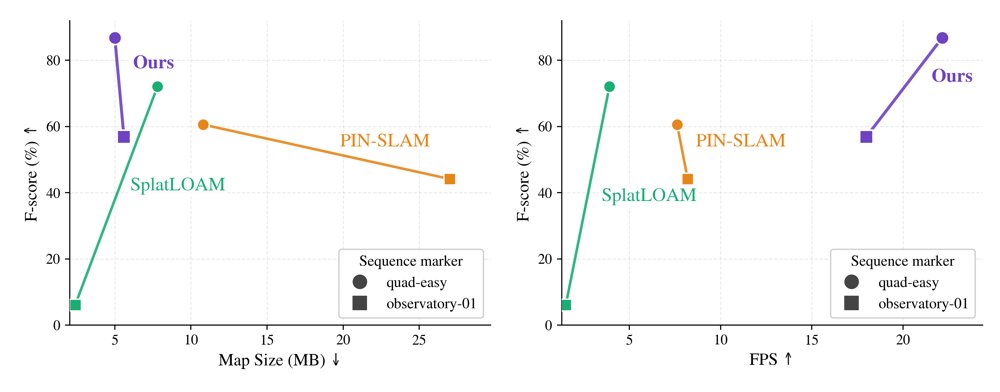
实验最有说服力的是质量-速度-地图大小的折中:相对 PIN-SLAM、Splat-LOAM 和 mapping-only upper-bound,它展示了在线估计 pose 下仍能保持较高 map fidelity 和实时 FPS。ablation 也比较直接地验证了 covariance initialization、normal feedback、map feedback 和 budget control 的作用。
但 evaluation 也有明显限制。第一,tracking 精度不是全面超过 KISS-SLAM/PIN-SLAM,论文真正强项是 dense mapping + real-time trade-off,而不是 odometry SOTA。第二,GT-pose mapping baselines 被作为 upper bound 是合理的,但与在线 SLAM 方法对比时,pose error 和 representation error 混在一起,归因不完全干净。第三,对动态场景、植被、雨雾、稀疏远距、不同 LiDAR pattern 的 stress test 不够;这些恰好是 covariance prior 最容易失效的地方。
Limitation
方法的核心前提是局部 covariance 可信。只要 G-ICP neighborhood 给出的 eigenstructure 稳定,后面的 scale、normal、control score、target covariance 都会受益;但如果场景是弱几何、重复结构、植被、动态物体或远距稀疏回波,这个共享信号会同时污染 tracking 和 mapping。这里的风险是错误会被耦合放大,而不是被隔离。
scalability 的上限也不是无限的。map management 降低了 persistent primitive count,但 optimization、rasterization、trackable subset selection 仍依赖地图规模和 keyframe policy。它更像是把线性增长的斜率压低,而不是从根本上获得 sublinear global map representation。
loop closure 处理偏工程化:pose graph 优化后对 Gaussian 做 keyframe-wise rigid update,而不是全局 Gaussian re-optimization。大闭环修正后,局部 surface continuity、overlap conflict 和 primitive covariance 可能不一致。文中未充分说明这种不一致在长距离重复 revisiting 下会不会积累。
泛化方面也要谨慎。多个参数与 sensor angular resolution、voxel size、scale bound、keyframe threshold 绑定;换机械式 LiDAR、solid-state LiDAR、不同 beam pattern 或不同速度平台,可能需要重新调参。所谓 generalization 更像几何先验在常见 outdoor LiDAR 数据上的迁移,而不是无需适配的跨传感器泛化。
Takeaway
- 第一,LiDAR GS-SLAM 的关键不在于把点云换成 Gaussian,而在于让 Gaussian 携带可用于 registration 的 uncertainty 和 surface structure;否则 dense map 只是负担。
- 第二,G-ICP covariance 是一个被低估的中间表示。
- 它可以迁移到任何需要 online dense representation 的系统中,作为 initialization、uncertainty、normal prior 和 budget allocation 的统一来源。
- 第三,未来 LiDAR dense SLAM 很可能沿着“explicit surface primitive + probabilistic tracking + adaptive capacity control”演化,而不是纯 neural field 或纯 voxel TSDF。
一句话总结
这篇论文把经典 G-ICP 的局部 covariance 重新组织成 LiDAR Gaussian map 的几何先验、预算控制信号和注册不确定性接口,是 LiDAR-only GS-SLAM 从“可重建”走向“在线可扩展可注册”的一类系统级演化。